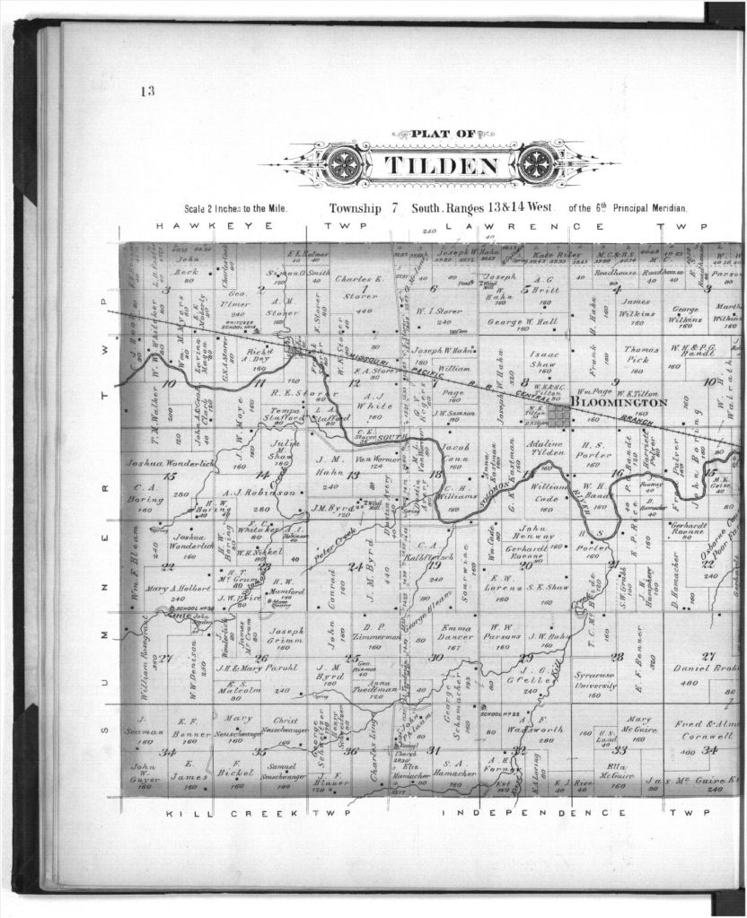
1900
Plat books are treasure maps that show exactly what lands an ancestor owned. How many acres did he/she own? What waterways were on or near the property? Did any railroads pass through the township? Who were that particular person’s neighbors? Where was the school house? Where were the cemeteries? Many questions tout the answers when viewing these maps.
Locating a plat book for Osborne County, Kansas, that was published in 1900 was a great find for me. I located both my great grandfather’s (W.I. Storer’s) and my second great grandfather’s (William Henry Stevens’) farms. W.I. and family lived in Tilden Township on lands his father had sold to him. W.I. owned 240 acres with easy access to the Missouri Pacific Railroad. The little village of Bloomington was close by where the post office was located along with a small general store and cafe. His brothers Willard and Charles lived on neighboring farms. They, too, had bought lands from their father. W. I.’s wife Sarah Almina lived near her brothers. The families were close in proximity if not also in reach. W.I. and Sarah had donated land from the southeast corner of their property to create the Bloomington Cemetery. (The location of this cemetery is marked on the plat.) By 1900, the Storers had lived in the county for almost 30 years.

1900
William Henry Stevens’ farm also had 240 acres, but it was located in Kill Creek Township (which is south of Tilden Township). The Will and his wife Isabella had been obtained the land through the Homestead Act of 1862. A portion of Kill Creek went across his farm. Some of his daughters had married nearby neighbors. Part of his family remained close by while others lived hundreds of miles away. By 1900, the Stevens family had lived in the county for almost 30 years. (By 1900, the county was 33 years old. These two families were some of her pioneer families.)
Plats are, indeed, treasures and treasure maps. Gold and precious gems of information are contained within their drawings. They aid in mapping out one’s research.